
It goes without saying that Google Maps is one excellent mapping and navigation tool, but there are also Google Maps alternatives that may be better for several reasons. Of course, the choice depends on how you want to use it ultimately.
There are several things to consider, like your choice of platform, whether you want to use it on your phone or the web. We won’t pry the reason why you’re looking for an alternative, but below are some choices of map apps that don’t start with “Google.”
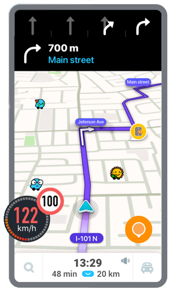
Waze
Download in App Store
Waze has managed to become so popular that Google bought it in 2013. Still, the company continues to exist as a separate entity from Google maps.
The community-driven map service is lauded for being intuitive and allowing users to quickly navigate. It has one of the best interactive systems, which helps drivers become aware of changes in traffic, hazards, speed cams, and other road objects.
With Waze, it’s easy to draw information on where the nearest police station is, the cheapest gas stations if there’s an accident or under-construction sites, and other info critical when traveling. You can even track your friends’ and other Waze users’ locations in real-time.
Pocket Earth
Though only for iOS users, Pocket Earth uses the popular OpenStreetMap data to give you up-to-date navigation no matter where you are in the world. You can even use it offline with all its organizational tools.
Pocket Earth has a lot of room for layers and extra info and you are given plenty of flexibility about what kind of info is shown on your maps. There’s even an option to add Wikipedia so you can see various points of interest on your map from the online encyclopedia.
You can download Pocket Earth for free but you can get a whole lot more for $5 and gain access to improved offline functionality and topographical maps.
Maps.me

Download in App Store
Available on all platforms, Maps.me has everything you need in a map app — public transport, cycling, traffic info, cycling navigation, and more. Like Google Maps, Maps.me also lets you use it without an internet connection, so whenever you are offline you will still know your way around even when in a foreign city.
The app benefits you in many kinds of settings. Like if you’re traveling to a different city, you will see all the important points of interest. For outdoorsy folks, the app has a regularly updated database of hiking trails all around the world. If you’re planning to go on a trip, simply bookmark a trail and send it to a friend or family, so they’ll know where you are.
The web version for Maps.me is excellent, too. It lets you choose from several categories and then you can filter to specific options suited to your preference.
Citymapper

Download in App Store
Citymapper is smaller in nature than Google Maps but performs its only job better than any software out there. Namely, this is a public transport app that tells you how to get around many of the world’s top cities by bus, tram, subway, and other modes of public transportation.
The app maintains an up-to-date directory of all public transportation routes in its supported cities, displays fares, and warnings, and lets you keep a list of your favorite places to ride to.
Bing Maps

Did you know that Bing Maps is as old as Google Maps? The map service, which is owned by Microsoft, was initially known as MapPoint until it took a catchy name. It’s packed with a lot of features, including traffic overlays and 3D views. For you more conventional mappers out there or people involved in town planning, there’s a complete ordinance survey map, too.
Bing tends to prefer different routes from Google, and when you compare them, Google generally comes out on top when it comes to travel planning. But if you’re looking for neat extra features like 3D views and OS maps, as well as your own detailed response to Street View, then Bing’s worth a pop.
BackCountry Navigator

Find yourself in the middle of God Knows Where, maybe on a mountainside or in a thick forest in the Canadian wilderness? Google Maps isn’t going to be a lot of help because it doesn’t detail the topography of the land as BackCountry would.
Crafted with hikers and outdoor types in mind, this map uses GPS waypoints and helps you to do such manual stuff as entering the longitude/latitude coordinates of your spot.
It’s the best travel buddy when you’re out and about and relies heavily on topographic maps from different established sources like OpenCycleMaps, USTopp, and even nautical maps from the NOAA RNC.
Navmii
Download in App Store
Navmii is a feature-rich map and navigation service that covers more than eighty-five nations. It provides simple features such as turn-by-turn navigation, bookmarking, closest points, search, and satellite view.
It offers warnings such as speed limits, traffic, speed cameras, construction sites, slowdowns, and more. All this is much easier with community-driven updates from other Navmii users. Navmii also works with Foursquare, TripAdvisor, and What3Words to provide personalized searches.
Other features include Google Street View, ETA indicator, Automated rerouting, HD maps, and full offline navigation support, but my favorite would be Driver Score, which will grade your driving based on the motion and GPS sensors on your screen! You’re curious right now, huh?
OsmAnd

Download in App Store
One of the best parts of this versatile open-source navigation app is the presence of offline maps that guarantee that anywhere you’re in the world – with or without signal – you’ll be able to navigate your way. The maps are very accurate, reminiscent of the esthetics of the Ordnance Survey maps, and regular changes ensure you’re never out of date.
You can break down what you see on your map, from things like toll roads and street lights to more specific variables like road surface and road condition. You can pick the roads you want to skip and multiple stops, and everything is super responsive once you’re on the road. The UI isn’t gorgeous, but it’s extremely adjustable, helping you to fine-tune which elements take precedence during navigation.